Baldwin County bulkhead guides. Find your shoreline.
Pick your waterfront to see the permit office, shoreline rules and storm record that apply there. Seven guides cover Orange Beach and Perdido, from Cotton Bayou and Terry Cove to Ono Island, Wolf Bay, the Gulf front, Perdido Beach and Lillian. Five cover Gulf Shores and Fort Morgan, from Little Lagoon to the Intracoastal, Bon Secour and Magnolia Springs. Five more cover the Eastern Shore of Mobile Bay, from Weeks Bay and Point Clear to Fairhope, Daphne and Spanish Fort.
Find your waterfront
Explore the coast. Find your starting point.
Seventeen guides across coastal Baldwin County, from the Orange Beach canals to the Eastern Shore of Mobile Bay. Each covers who issues permits there, what the water does and what to check on your wall.
Full local guide
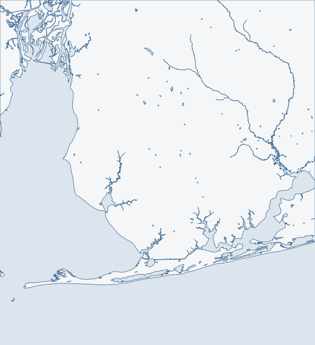
Choose a label to open local resources →Tap a community on the map or below ↗
Land and water: U.S. Census Bureau TIGERweb, 2026. Reference points: USGS GNIS and NOAA CO-OPS. General orientation only; not a survey, flood map or service boundary.
Your local starting point
Find your community.
Choose a guide for local maps, permit starting points and the records to gather for your property.
Pre-bid checklist for a Cotton Bayou or Terry Cove wall
Perdido Pass runs between Florida Point and Alabama Point. The State Route 182 bridge crosses it on two fixed spans, with 54 feet of clearance over the pass channel and 41 feet over the Cotton Bayou channel. Past the bridge the dredged channel forks. One arm runs north into Terry Cove and Johnson Cove. The other runs east toward Bayou St. John. Cotton Bayou sits on the west side, about 0.7 mile above the entrance, and several small-craft facilities line the coves.
Bayou St. John is the marked route from Perdido Pass to the Intracoastal Waterway. Old River enters the pass from the east, and the Florida-Alabama line runs through it. Robinson, Walker and Bird islands sit off the pass. Alabama's end of Perdido Key lies east of it. Census boundary layers put Caswell inside Orange Beach but place the points for Robinson Island, Walker Island, Bayou St. John and Old River outside the city polygon.
Ono Island is a private gated community at the mouth of Perdido Bay. Bayou St. John borders it on the north and Old River on the south. Goat Bayou and Goat Point mark the west end. Bellville Bay and Point Ono mark the east end. Census boundary layers place the island in no incorporated place, and the Orange Beach city limit stops west of it.
The Intracoastal Waterway runs through Arnica Bay, Bay La Launch and Wolf Bay, from Mile 166.8E to Mile 160.0E. This shore meets both barge traffic and open fetch (long stretches of open water). Arnica Bay and Bay La Launch link Perdido Bay on the east with Wolf Bay on the west. Roberts Bayou, locally called Pirates Cove, opens off the north side of Arnica Bay.
The City of Orange Beach holds the Gulf front from near longitude -87.636, the Gulf Shores line, east through Romar Beach and Alabama Point. Across the pass its polygon continues along Perdido Key to about -87.514. Little Lake and Middle River sit behind the dunes at Romar Beach. Gulf State Park runs four public accesses here: Romar Beach, Cotton Bayou, Alabama Point East and Shell Beach. They are state land inside the city.
The west shore of middle Perdido Bay runs 6 to 20 feet deep. Soldier Creek, with a wide stretch called Crystal Lake, and Palmetto Creek drain to it. Josephine lies south of the town, along Roberts Bayou and the Intracoastal route. The Perdido Bay shoreline in the watershed plan runs about 14.7 miles from near Ross Point to the mouth of the Perdido River.
Lillian sits on the north shore of upper Perdido Bay near the Alabama-Florida line. The Census Bureau counts it as a place with no municipal government, home to 1,330 residents in 2020. Most of the ZIP area lies outside that census boundary, so a Lillian mailing address says little about who permits the shore. The Town of Elberta (1,974 residents) sits inland, and its limits do not reach the Perdido Bay shoreline tested at Suarez Point or Lillian.
Gulf Shores reaches west to about longitude -87.80, so Little Lagoon, Willet Point and West Beach all sit inside the city. The city counted 15,014 residents in 2020. The city describes the lagoon as a brackish lake about 8 miles long and three-quarters of a mile wide. It sits between Bon Secour National Wildlife Refuge on the west and Gulf State Park on the east. West of the lagoon's west end, the shore leaves the city and the Fort Morgan Peninsula begins.
The City of Gulf Shores straddles the Intracoastal Waterway and reaches north to about latitude 30.334. Yet both Oyster Bay map points test outside the city, even though the city surrounds much of that area. The waterway opened in 1937 and gave the Gulf Shores area its first easy access, and the Alabama Supreme Court upheld the city's incorporation in 1958. The waterway runs through a long land cut from Wolf Bay at Mile 160.0 through Oyster Bay to Bon Secour Bay at Mile 151.0.
West of about longitude -87.80, the Gulf-front land that includes Gulf Highlands, Cedar Grove, Palmetto Beach, Navy Cove and Fort Morgan lies in no incorporated place. The county's building jurisdiction covers all unincorporated land. Many peninsula lots share the Gulf Shores ZIP area, and about 62 of its 135 square kilometers of land are in no incorporated place. A Gulf Shores mailing address therefore does not mean a Gulf Shores permit.
Census data list Bon Secour as a place without a municipal government, with 1,754 residents in 2020. Only about half of the land in its ZIP area is inside that census boundary, so a Bon Secour address does not settle who permits a lot. The river rises in Foley, flows about 8 miles south and southwest into Bon Secour Bay, and reaches Oyster Bay through its South Fork. It is about 2,000 feet wide at the mouth.
The Town of Magnolia Springs counted 811 residents in 2020. It is one small polygon of about 2.65 square kilometers. The mouth of the Magnolia River and Weeks Bay fall outside it, so the lower river is unincorporated county even where addresses say Magnolia Springs. The town's history page says boathouses line each shore of the river, which was once the highway for steamers and sailboats.
Weeks Bay is a small, shallow bay of about 1,718 acres on the east side of Mobile Bay. Coast Pilot gives it an average depth of 2 to 5 feet, with a marked channel of about 4 feet leading across to the Fish River. Small boats run up the river to Marlow. Two fixed bridges limit what can follow. US 98 at Yupon has 35 feet of clearance. State Route 32 at Marlow, about 5.5 miles up, has 22 feet. The whole watershed covers about 203 square miles and touches nine towns.
Point Clear records to pull before you ask for bids
Point Clear sits on the east side of Mobile Bay, about 16 miles above the entrance. A light marks shoals that run west from Great Point Clear, and a privately dredged channel, reported at 5.5 feet in 1999, leads to a yacht harbor. The Point Clear census area counted 2,076 residents in 2020. Battles Wharf and Loyola Villa fall inside it. Mullet Point and Barnwell fall outside it.
Fairhope counted 22,477 residents in 2020. Its limits run from about latitude 30.512 to 30.582 in 44 separate pieces, with unincorporated gaps between them. The shore is a bluff above Mobile Bay. The municipal pier, 1,448 feet long, was destroyed by Katrina in 2005 and rebuilt in 2006. Fly Creek, to the north, has a federal channel 6 feet deep and 80 feet wide.
Daphne was incorporated on July 8, 1927, and counted 27,462 residents in 2020, the most of any coastal Eastern Shore city. Its bay-front limits begin about latitude 30.582 and include Village Point. To the south, Montrose has no town of its own. The bay shore runs from Red Bluff and Ragged Point north past Daphne's bluff, with Yancey Branch, Jordan Brook and Rock Creek draining into it.
Spanish Fort was incorporated on July 19, 1993. It counted 10,049 residents in 2020. The city grew from 1,542 acres to about 17,561. Its limits run west from the bluff across the whole Causeway corridor to roughly the county line, and Meaher State Park lies inside them. Named waters include the Blakeley and Apalachee rivers, Bay John, Justins Bay and Choccolatta Bay. The lower delta lies north of the road and upper Mobile Bay lies south of it.